The air above us is teeming with tiny particles that range from about hundreds of particles per cubic centimeter of air to tens of thousands. It is now generally recognized that aerosols have substantial impact on the energy budget of the atmosphere, the formation of clouds and precipitation. A single particle in the air can have a mass of billionth of a gram or less and when added up these particles together weigh between a few micrograms/m3 to a few hundreds of a microgram/m3, depending on the location and pollution levels.
The most common method for measuring the amount of these particles (commonly referred to as aerosols) is collecting them on a filter paper from a ground-based station to give a measure of mass of the particles at that location. Measuring the turbidity (or the reduction in the incoming light from the sun which is reported as a Aerosol Optical Depth) of the atmosphere above to estimate the aerosol mass from the surface to the top of the atmosphere is another widely used method. However, it has always been a problem to predict how the concentration of these aerosols changes as we go up from the ground to higher altitudes.
Knowing this vertical profile of aerosols is critical for understanding the impact of aerosols on weather and climate. Unfortunately, there is sparse observational data describing the vertical profiles of aerosols and the aerosol optical depth (AOD) as a function of altitude. The U.S. Department of Energy Atmospheric Radiation Measurement (ARM) program maintains a number of instruments that use low power lasers (the instrument is called Micropulse Lidar, MPL) to measure the turbidity of the atmosphere above the ground.
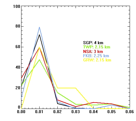
For the first time, a long-term average of AOD as a function of the height above the ground, using data from MPL observations, was obtained by Argonne researchers. The climatology was generated at different locations worldwide during the four year period from 2007-10 at five different ARM program sites — three permanent sites (Southern Great Plains (SGP) in North Central Oklahoma; Tropical Western Pacific (TWP); located at Darwin, Australia; and the North Slope Alaska (NSA) site located at Barrow, Alaska, as well as two mobile facility sites (Grasiosa Island in the Azores, Portugal and Black Forest region of Germany).
Most aerosols were found to be confined to 0-2 km from the ground surface (approximately the planetary boundary layer region) at all sites; however, all sites exhibited measurable aerosols well above 2km, with different height maxima. The entire data set demonstrates large day-to-day variability at all sites. Significant inter-annual variability was observed at the SGP site. Clear seasonal variations in AOD (z) profiles exist for all five sites. These results will aid the scientific community in understanding aerosol properties and boundary layer dynamics and in improving the incorporation of aerosol radiative effects into global climate models.
Reference: Micropulse Lidar-Derived Aerosol Optical Depth Climatology at ARM Sites Worldwide, Durga Kafle and Richard Coulter, Journal of Geophysical Research, doi:10.1002/jgrd.50536).