EVS supports integrated assessment, environmental management, natural and cultural resource analyses, and basic science programs. The division has expertise in ecology, geology, hydrology, atmospheric science, spatial analysis, computer science, geography, social and cultural sciences, environmental engineering, and ecological and human health risk assessment. EVS staff conducted remote sensing work using very high-resolution images to support long-term monitoring of the Riverside East solar energy zone in California, a priority area for utility scale solar energy development identified by the Bureau of Land Management in October 2012. This work supported identification of vegetation density, desert pavement, and erosion-sensitive areas. In addition, Argonne is an Federal Aviation Administration (FAA) approved center for use of sUASs, allowing EVS remote-sensing staff to support sUAS data collection design and analysis.
Collection of high-resolution images and development of algorithms for image processing and interpretation assists in natural and cultural resource monitoring and management. EVS researchers perform the following tasks:
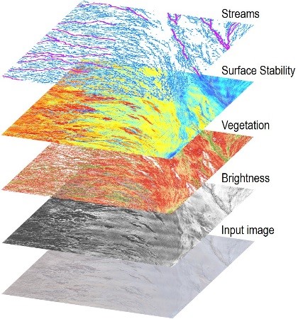
Assess and monitor changes in individual plants and vegetation communities by customizing image processing algorithms; extract and map detailed ephemeral stream networks using image transformations; map land surface stability or the risk of erosion; monitor invasive plant species; model seasonal habitat suitability over large areas.
Package remote-sensing methodologies for cost-effective, multiscale ecological and environmental monitoring to make ecosystems in arid and semiarid lands more sustainable.
Supplement archaeological field surveys with aerial assessment and mapping of cultural features and monitoring land surface changes over time for assessing impacts on cultural sites.
Formulation of predictive models provides managers with tools to inform field survey planning, testing scenarios, and analyzing future states. EVS researchers develop predictive models for plant productivity to facilitate landscape design; species occurrences; and greater sage-grouse population trend analysis using individual-based modeling and geospatial layers.
EVS remote-sensing staff develop methods to obtain difficult-to-collect measurements across extensive water bodies. We then estimate water depth of critical backwater habitats along a turbid river by applying optical remote sensing in conjunction with advanced statistical modeling.
EVS researchers develop methods to obtain measurements that indicate the integrity or health of vegetated lands. We then estimate carbon exchange between the atmosphere and land surfaces using hyperspectral remote sensing, statistical modeling, and machine learning.
Timely and cost-effective collection of very detailed imagery allows researchers to acquire highly customized images to meet specific project needs. The following are examples of data collection activities that can be achieved using sUASs:
Collect multi-temporal images with high spatial alignment to accurately detect and monitor land surface changes to assess impacts and monitor mitigation effectiveness.
Collect high-resolution thermal infrared imagery to examine the integrity of infrastructure.