Understanding the characteristics and patterns of precipitation is crucial for understanding land-climate interactions, for extreme event monitoring, and for water resource management. While. rain gauge networks provide observations with high temporal resolution, however, obtaining a spatially representative precipitation field from rain gauges is more problematic, requiring collecting a large number of observations at various locations to account for terrains, microclimate, and vegetation variability.
To address this issue, researchers from Argonne National Laboratory, together with colleagues from George Mason University and Ohio State University, have devised an automated method that identifies the optimal locations of rain gauges.
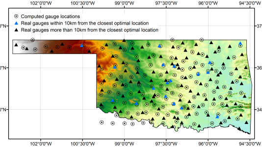
Key to the new strategy is the use of so-called centroidal Voronoi tessellations, or CVTs, whereby a space is optimally partitioned corresponding to an optimal distribution of generators.
“Although other types of Voronoi constructions have been explored, this is the first application of the CVT methodology to modeling rainfall data and specifically to optimizing rain gauge placements,” said Zichao (Wendy) Di, an assistant computational scientist in Argonne’s Mathematics and Computer Science Division.
The research team focused on two distinct regions: Oklahoma, characterized by a west-to-east (dry-to-wet) rainfall pattern, and the Alto-Adige in northern Italy, which has a mean annual precipitation varying from ~500 mm in the northwest to ~1700 mm in the southeast. Using these precipitation patterns, the researchers first constructed a density map based on the spatiotemporal correlations in a specific region. The map was then used as input for constructing the CVT, and the resulting minimization problem was solved to obtain optimal rain gauge locations for that region.
“Experiments show that in comparison with other methods, our model is simpler, owing to the natural minimization properties of CVTs,” Di said. “Moreover, because the model is based on global satellite observations, it can be used to choose new gauge locations in almost any geographical area.”
This research is documented in the following paper: Z. Di, V. Maggioni, Y. Mei, M. Vazquez, P. Houser, and M. Emelianenko, “Centoidal Voronoi tessellation based methods for optimal rain gauge location prediction,” Journal of Hydrology, 584, May 2020 https://www.sciencedirect.com/science/article/pii/S0022169420301116?via%3Dihu
A preprint version is available at https://arxiv.org/pdf/1908.10403.pdf.